

Description
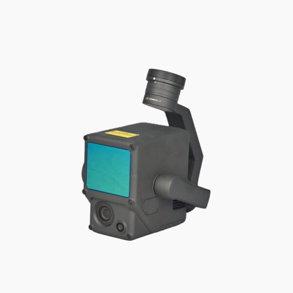
DJI Zenmuse L1 LiDAR: Revolutionizing 3D Mapping With Advanced LiDAR Technology
The DJI Zenmuse L1 LiDAR is an innovative LiDAR solution designed to elevate 3D mapping, surveying, and inspection tasks to new heights. This cutting-edge payload integrates seamlessly with the Matrice 300 RTK, offering professionals across industries the precision and efficiency they need for their most demanding projects. Whether you’re involved in infrastructure inspection, environmental monitoring, or construction planning, the Zenmuse L1 is the ideal tool for capturing accurate, detailed 3D models.
DJI Zenmuse L1 LiDAR: Exceptional Performance With Advanced LiDAR Technology
The DJI Zenmuse L1 LiDAR leverages advanced LiDAR Technology, providing a detection range of up to 450 meters under optimal conditions and a system accuracy of 10 cm horizontally and 5 cm vertically at 50 meters. This precision makes these Lidars a game-changer for professionals requiring exact measurements and data integrity. These LiDAR Sensors For Drones can generate up to 480,000 points per second with multiple returns, ensuring comprehensive data collection even in complex environments.
Visualize Data as You Fly: Livox Lidar Module
-Frame Lidar with up to 100% effective point cloud results
-Detection Range: 450m (80% reflectivity, 0 klx) / 190 m (10% reflectivity, 100 klx)
-Effective Point Rate: 240,000 pts/s
-Supports 3 Returns[3]
-Non-repetitive scanning pattern, Repetitive scanning pattern

Everything in View: RGB Camera
– 20MP
– 1-inch CMOS
– Mechanical Shutter

DJI Zenmuse L1 LiDAR: Industry-Leading Specifications
General Specifications:
- Product Name: Zenmuse L1
- Dimensions: 152×110×169 mm
- Weight: 930±10 g
- Power Consumption: Typical: 30 W; Max: 60 W
- IP Rating: IP54
- Supported Aircraft: Matrice 300 RTK
- Operating Temperature Range: -20° to 50° C (-4° to 122° F); 0° to 50° C (32° to 122° F) with RGB mapping camera
- -20° to 60° C (-4° to 140° F) is the storage temperature range.
System Performance:
- 450 m at 80% reflectivity, 0 klx; 190 m at 10% reflectivity, 100 klx is the detection range.
- Point Rate: Single return: max. 240,000 pts/s; Multiple return: max. 480,000 pts/s
- Accuracy of System (RMS 1σ): 10 centimeter horizontally at 50 m; 5 cm vertically at 50 m
- Reflectivity, Height, Distance, as well as RGB Real-time Point Cloud Coloring Modes
LiDAR Specifications:
- Accuracy of Ranging (RMS 1σ): 3 cm at 100 meters
- Maximum Returns Supported: 3
- There are two types of scan modes: Non-repetitive as well as repetitive.
- Field of View (FOV): Non-repetitive scanning: 70.4° (horizontal) × 77.2° (vertical); Repetitive scanning: 70.4° (horizontal) × 4.5° (vertical)
- (IEC 60825-1:2014) Laser Safety: Class 1 (Safety of the eyes)
Inertial Navigation System:
- IMU Update Frequency: 200 Hz
- Accelerometer Range: ±8 g
- Angular Velocity Meter Range: ±2000 dps
- Yaw Accuracy (RMS 1σ): 0.15° subsequent to post-processing, 0.3° in real time.
- Pitch / Roll Accuracy (RMS 1σ): Real-time: 0.05°, Post-processing: 0.025°
Auxiliary Positioning Vision Sensor:
- Resolution: 1280×960
- Field of View (FOV): 95°
RGB Mapping Camera:
- Size of these LiDAR Sensors For Drones: 1 inch
- Effective Pixels: 20 MP
- Photo Size: 5472×3078 (16:9); 4864×3648 (4:3); 5472×3648 (3:2)
- The equivalent focal length is 8.8 mm or 24 mm.
- Shutter Speed: Mechanical: 1/2000 – 8 s; Electronic: 1/8000 – 8 s
- ISO Range: Photo: 100 – 12800 (Manual), 100 – 3200 (Auto); Video: 100 – 6400 (Manual).
- Aperture Range: f/2.8 – f/11
- Supported File System: FAT (≤32 GB); exFAT (>32 GB)
- Photo Format: JPEG
- Video Format: MOV, MP4
- Video Resolution: H.264, 4K: 3840×2160 30p
Gimbal:
- Stabilized System: 3-axis (tilt, roll, pan)
- Angular Vibration Range: 0.01°
- Mount: Detachable DJI SKYPORT
- Mechanical Range: Tilt: -120° to +30°; Pan: ±320°
- Operation Modes: Follow/Free/Re-center
Data Storage:
- Raw Data Storage: Photo/IMU/Point cloud data storage/GNSS/Calibration files
- Supported microSD Cards: Sequential writing speed 50 MB/s or above, UHS-I Speed Grade 3 rating or above, Max capacity: 256 GB
- Recommended microSD Cards: SanDisk Extreme 128GB UHS-I Speed Grade 3, Lexar 1066x 128GB U3, Samsung EVO Plus 128GB
Post-processing Software:
- Supported Software: DJI Terra
- Data Format: DJI Terra supports exporting standard format point cloud models in PNTS/LAS/PLY/PCD/S3MB formats
DJI Zenmuse L1 LiDAR: Versatile Applications Across Industries
The DJI Zenmuse L1 LiDAR is a versatile tool that caters to a wide array of industries. Its advanced LiDAR Sensors For Drones allow for precise 3D mapping and surveying, making it invaluable in construction, forestry, mining, and infrastructure inspection. The LiDAR Scanner‘s ability to capture detailed data in various lighting and weather conditions ensures that professionals can rely on the Zenmuse L1 for consistent, high-quality results.
In the construction industry, the DJI Zenmuse L1 LiDAR is essential for site planning and monitoring, providing accurate measurements and real-time data that improve decision-making processes. For forestry management, these Lidars help in vegetation analysis, allowing for the efficient monitoring of forest health and growth. The Zenmuse L1 is also crucial in infrastructure inspection, where its high precision enables the detection of structural issues that may not be visible to the naked eye. The fair LiDAR Price makes this product worth buying.
Point Cloud LiveView
Real-time point clouds provide immediate insights onsite, so operators are informed to make critical decisions quickly. You can also verify fieldwork quality by checking point cloud data immediately after each flight.
Measurement and Annotation
Acquire and communicate critical dimensions on the point cloud model using measurements and annotations.
DJI Zenmuse L1 LiDAR: Seamless Integration With DJI Ecosystem
Designed to integrate perfectly with the DJI MATRICE 300 RTK, the DJI Zenmuse L1 LiDAR ensures that users can take full advantage of DJI’s robust UAV platform. The combination of the Matrice 300 RTK and the DJI L1 provides a powerful solution for any professional seeking to leverage UAV LiDAR Technology in their operations. This synergy between hardware and software enables users to capture, process, and analyze data efficiently, streamlining workflows and improving productivity. The fair LiDAR Price makes this product worth buying.
DJI Zenmuse L1 LiDAR: Competitive Pricing And Availability
The LiDAR Price for the DJI Zenmuse L1 LiDAR is reflective of its advanced capabilities and the value it brings to professional workflows. While the initial investment may seem significant, the long-term benefits of owning such a precise and reliable LiDAR Sensor make it a worthwhile purchase. For specific pricing details and availability for these Lidars, it’s recommended to contact authorized DJI dealers.
DJI Zenmuse L1 LiDAR: Stocks Are Running Out! Buy This Product Now!
The DJI Zenmuse L1 LiDAR is more than just a LiDAR Sensor — it’s a comprehensive solution that transforms the way industries approach 3D mapping and surveying. With its exceptional performance, seamless integration with the Matrice 300 RTK, and versatility across various applications, the Zenmuse L1 is a must-have for any professional looking to enhance their operations with cutting-edge LiDAR Technology. Whether you’re in construction, forestry, or infrastructure inspection, the DJI Zenmuse L1 is the tool you need to achieve unparalleled accuracy and efficiency. The fair LiDAR Price makes this product worth buying.

Reviews
There are no reviews yet.