


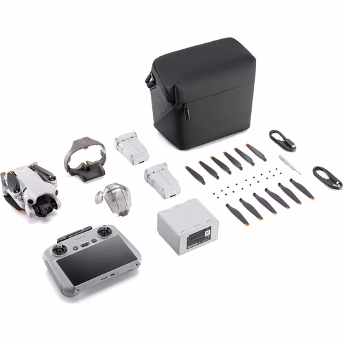
Description
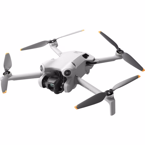
DJI Matrice 4E – ( DJI Matrice 4 Enterprise Edition)
The DJI Matrice 4 Series is a powerful line of commercial-grade drones designed for a wide range of industrial applications. Featuring advanced flight technology, the Matrice 4 Series offers enhanced reliability, safety, and performance, making it ideal for surveying, inspections, agriculture, and more. The drones come with versatile payload options, allowing users to carry various sensors and cameras for specialized tasks. With long flight times, rugged build quality, and cutting-edge intelligence, the Matrice 4 Series provides businesses with the tools to capture detailed aerial data and improve operational efficiency.
Enjoy faster, safer flights with a rapid 15-second takeoff, speeds up to 21 m/s, a 25 km transmission range via 4G Enhanced Transmission, and an impressive 49-minute flight time.
Precision mapping is streamlined with factory-calibrated cameras, distortion correction 2.0, and multi-directional capture, boosting efficiency by up to 40%.
Intelligent Multi-Sensor Compact Drone with AI
In-depth Features of DJI Matrice 4E
DJI Matrice 4E Payload

Wide-Angle Camera
4/3 CMOS, 20MP Effective Pixels , f/2.8-f/11, Format Equivalent: 24 mm, Mechanical Shutter
Medium Tele Camera
1/1.3″ CMOS, 48MP Effective Pixels, f/2.8, Format Equivalent: 70 mm
Tele Camera
1/1.5″ CMOS, 48MP Effective Pixels, f/2.8, Format Equivalent: 168 mm
Laser Range Finder
Measurement Range: 1800 m (1 Hz); Oblique Incidence Range (1:5 Oblique Distance): 600 m (1 Hz) Blind Zone: 1 m; Range Accuracy (m): ± (0.2 + 0.0015 × D)
The Age of Intelligent Flight
Intelligent Operations With AI
- Real-Time AI Detection of people, vehicles, and boats
- Intelligent Features like FlyTo, POI, Smart Track, and Cruise
- Observed View, Line & Area Drawing with LRF
DJI Matrice 4E Crystal Clear Vision

- New 3x camera improves continuous zoom and image clarity
- New 7x camera with 112x hybrid zoom captures license plates from 250m
- Foreground stabilization, EIS, and electronic dehazing
Excels In Low-Light

- Improved obstacle avoidance in low-light environments
- Night scene mode supported
- Equipped with NIR auxiliary light and spotlight payload
Faster & Safer
- Rapid takeoff within 15s
- 25 km max transmission range; 4G Enhanced Transmission
- Supporting D-RTK 3 Relay station
- Anti-GNSS-interference
- Improved GNSS & Vision Fusion Positioning
High-Efficiency Precision Mapping
- 5-Directional Oblique Capture efficiency increased by 40%
Upgraded Accessories
- Gimbal-Following Spotlight illuminates objects 100m away
- Real-time Voice Speaker and Spotlight payloads work together
- D-RTK 3 Multifunctional Station supports relay, base station, and rover mode.
Intelligent Operations With AI
AI Power for Smarter Operations
The built-in AI model optimizes the detection of vehicles, vessels, and individuals during search and rescue missions or routine operations. It supports seamless switching between AI models, offering versatility for a wide range of applications. With high-resolution grid photography and advanced tracking capabilities, it ensures greater operational efficiency and accuracy.
A Laser Range Finder for Precise Measurements
The laser rangefinder (LRF) provides real-time, precise measurements for essential operations. Equipped with tools such as pinpointing, line drawing, and area calculation, it allows users to efficiently mark target locations or measure areas like wildfires. Information can be seamlessly shared with team members through the DJI Pilot QR code or FlightHub 2, enhancing collaboration and streamlining workflows.
Observed Range Recording
DJI Pilot 2 improves situational awareness by marking the center of the camera frame and the ground area being observed. The surveyed area is displayed on a map, making it an essential tool for patrols and rescue missions in mountainous regions or areas with limited landmarks.
Efficient Flight, Intelligent Operations
Cruise
Cruise control mode enables the drone to fly in a set direction without requiring constant control stick input, making long-distance flights easier and reducing pilot fatigue.
FlyTo
In emergency or disaster scenarios, the drone autonomously adjusts its flight path and speed based on environmental conditions, ensuring it reaches the designated location efficiently without requiring manual intervention.
Smart Track
Smart Track enables precise subject positioning with automatic zoom adjustments, making it easy to switch between subjects. It can also automatically reacquire a subject if temporarily obscured, ensuring continuous tracking and monitoring.
Point of Interest (POI)
Point of Interest (POI) mode allows for continuous observation and 3D modeling of structures by orbiting a designated area. This functionality enhances the efficiency of fixed-point observation and modeling tasks.
Excel In Low-Light Environments
Night Scene Mode
The Matrice 4 series introduces an upgraded night mode with Full-Color Night Vision, offering three modes and two levels of advanced noise reduction. Equipped with an IR Cut Filter and NIR auxiliary light, it delivers exceptional performance in low-light conditions, ensuring clear visibility of search and rescue subjects even in total darkness.
Smart Low-Light Photo
The Matrice 4 series cameras feature larger apertures and advanced low-light technology, ensuring outstanding performance and enhanced efficiency in low-light environments, including dusk and nighttime operations.
Low-Light Fisheye Omnidirectional Sensing
The Matrice 4 series is equipped with six high-definition low-light fisheye vision sensors, boosting its capabilities for low-light positioning and obstacle avoidance. This advanced system enables automatic obstacle avoidance, intelligent rerouting, and safe return, even in complex urban low-light environments.
Crystal Clear Vision: Reveal Every Detail
Capture Every Detail from A Distance
Enhanced Medium Telephoto
The Matrice 4 series includes a medium telephoto camera, designed to enhance medium-range inspection tasks. It can identify screws and cracks from a distance of 10 meters during power line or bridge inspections and accurately read instrument data at substations.
Super Resolution Telephoto
The Matrice 4 series telephoto camera offers exceptional clarity with its 48 MP resolution, capturing intricate details from signs up to 250 meters away. The Matrice 4T further enhances performance with an IR-Cut Filter, ensuring reliable operation around the clock.
Foreground Stabilization for Telephoto Imagery
The upgraded telephoto stabilization keeps foreground subjects stable and clear, even at 10x zoom or higher. This improvement enables precise detail capture in critical scenarios like public safety missions and inspection operations.
Electronic Dehazing: Crystal-Clear Clarity
The Matrice 4 series incorporates Electronic Dehazing with three adjustable modes (Low, Medium, High), delivering optimal imaging clarity in challenging conditions such as smog or high humidity. This feature adapts seamlessly to diverse operational environments and requirements.
Precision Mapping: Efficient and Effortless
Rapid 0.5-Second Interval Shooting
The Matrice 4E wide-angle camera enables rapid 0.5-second interval shooting in both orthophoto and oblique photography modes, facilitating high-speed aerial surveys from multiple angles. With mapping flight speeds of up to 21 meters per second, it significantly boosts operational efficiency.
Multi-Directional Capture: Efficiency Redefined
5-Directional Oblique Capture
The Matrice 4 series features 5-directional oblique capture, enabling the gimbal to rotate intelligently and capture images from various angles based on the survey area. This innovation achieves the equivalent of multiple shots in a single flight, significantly enhancing the efficiency of oblique photography for small drones compared to earlier models.
3-Directional Ortho Capture
The Matrice 4E features 3-directional ortho capture, enabling lateral image collection during ortho mapping tasks to reduce lateral overlap. A single flight can cover up to 2.8 square kilometers without the need for additional elevation optimization flight routes, ensuring precise elevation accuracy. Paired with enhanced DJI Terra capabilities, it boosts reconstruction efficiency while maintaining exceptional quality.
Smart 3D Capture: Accurate and Efficient Modeling
The DJI Matrice 4E features Smart 3D Capture, enabling users to generate a rough model directly on the remote controller. Using this model, the system quickly creates precise mapping routes near a structure’s surface, facilitating detailed measurements and modeling of irregular buildings. It also offers virtual space route visualization and waypoint photo displays, ensuring easy assessment of flight safety and coverage areas for efficient and accurate 3D capture.
Distortion Correction Enhances Precision
Distortion Correction 2.0 delivers highly accurate in-camera distortion correction with residual distortion under 2 pixels. Each Matrice 4E wide-angle camera is factory-calibrated, and when paired with DJI Terra, it greatly enhances reconstruction accuracy.
Auto Generated Surveying Operation Report
Upon mission completion, DJI Pilot 2 automatically generates a comprehensive survey quality report. This report provides key details, including photo points, RTK status, and photo parameters. Any detected anomalies can be resolved on-site by capturing additional photos, minimizing the need for repeat visits.
Safe Flight, Worry-Free Operation
Fusion Positioning Ensures Safer Return-to-Home
The Matrice 4 series features an integrated DJI RTK module with extended L5 frequency band support and a GNSS + Vision Fusion Positioning and Navigation System. This advanced technology enables visual positioning updates for the return-to-home point, allowing rapid takeoff within 15 seconds. Even in GNSS-denied environments, the drone can successfully complete the return-to-home process, effectively overcoming signal obstructions and interference commonly found in urban settings.
Intelligent Guidance for Unobstructed Flights
The DJI RC Plus 2 Enterprise remote controller, when connected to the internet, can load terrain elevation maps and preload detailed maps. This capability supports automatic path planning for obstacle avoidance, ensuring safe operations in challenging scenarios like nighttime missions or mountainous terrain. With a 5-directional vision assist system and downward vision sensors, the drone offers comprehensive visibility, enhancing safety and operational reliability.
Achieve New Heights in Video Transmission
The O4 Enterprise video transmission system sets a new standard for performance in challenging environments. Featuring an advanced 8-antenna system on the Matrice 4 series and a high-gain antenna on the remote controller, it achieves a transmission range of up to 25 kilometers. With a download bandwidth of 20MB/s—more than double the bitrate of the Mavic 3 Enterprise Series—it ensures precise and stable route uploads and material downloads.

Reviews
There are no reviews yet.