
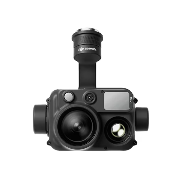
Description
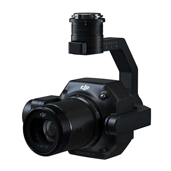
DJI Zenmuse P1 – RGB Solution for Enterprise Drones
Mastering Precision With The DJI Zenmuse P1
The DJI Zenmuse P1 is a high-performance full-frame camera designed for precision aerial mapping and surveying. With a 45MP sensor and 3 cm horizontal accuracy, it’s perfect for professionals in construction, agriculture, mining, and more. Built for the DJI Matrice 300 RTK, the DJI P1 offers robust performance in challenging environments, delivering detailed data and stunning imagery every time.
The New Benchmark for Aerial Surveying
The Zenmuse P1 integrates a full-frame sensor with interchangeable fixed-focus lenses on a 3-axis stabilized gimbal. Designed for photogrammetry flight missions, it takes efficiency and accuracy to a whole new level.
Technical Specifications Of The DJI Zenmuse P1:
General-
Product Name: DJI ZENMUSE P1
Dimensions: 198×166×129 mm
Weight: Approx. 800 g
Power: 20W
IP Rating: IP4X
Supported Aircraft: Matrice 300 RTK
Operating Temperature Range: -20° to 50° C (-4° to 122° F)
Storage Temperature Range: -20° to 60° C (-4° to 140° F)
Absolute Accuracy: Horizontal: 3 cm, Vertical: 5 cm* (*Using Mapping Mission at a GSD of 3 cm and flight speed of 15 m/s, with a 75% front overlap rate and a 55% side overlap rate.)
Camera-
Sensor: Full-frame (35.9×24 mm)
Sensor size (Max video recording area): 34×19 mm
Effective Pixels: 45MP
Pixel size: 4.4 μm
Supported Lenses:
DJI DL 24mm F2.8 LS ASPH (FOV 84°)
DJI DL 35mm F2.8 LS ASPH (FOV 63.5°)
DJI DL 50mm F2.8 LS ASPH (FOV 46.8°)
Supported SD Cards: UHS-I rating or above, Max capacity: 512 GB
Storage Files: Photo / GNSS Raw Observation Data / Image Log File
Photo Size: 3:2 (8192×5460)
Operation Modes: Photo, Video, Playback
Minimum Photo Interval: 0.7 s
Shutter Speed:
Mechanical Shutter: 1/2000*-1 s
Electronic Shutter: 1/8000-1 s (*Aperture value no larger than f/5.6)
Aperture Range: f/2.8 – f/16
ISO Range:
Photo: 100-25600
Video: 100-25600
Video-
Video Format: MP4, MOV
Video Resolution:
16:9 (1920×1080)
16:9 (3840×2160) (Only 35mm lens supported)
Frame Rate: 60fps
Gimbal-
Stabilized System: 3-axis (tilt, roll, pan)
Angular Vibration Range: ±0.01°
Mount: Detachable DJI SKYPORT
Mechanical Range:
Tilt: -130° to +40°
Roll: -55° to +55°
Pan: ±320°
Efficiency to Cover It All Full-frame Camera
- 45MP Full-frame Sensor
- 4.4μm Pixel Size
- Low-noise, high sensitivity imaging extends daily operational time
- Take a photo every 0.7 s during the flight

Flexibility to Capture It All
Multiple Fixed-focus Lens Options
- Global Mechanical Shutterßl, Shutter Speed 1 /2000 Seconds
- Sends the median exposure pulse in microseconds
- Supports 24/35/50mm lenses with DJI DL mounts

Applications Of DJI Zenmuse P1
The DJI Zenmuse P1 is a versatile tool for professionals in various industries, offering a combination of high precision, durability, and imaging performance for aerial surveying and mapping. Key applications include:
- Aerial Mapping And Surveying: The DJI P1’s 45MP full-frame sensor delivers precise data with a horizontal accuracy of 3 cm and vertical accuracy of 5 cm, making it an ideal tool for large-scale mapping projects. It’s perfect for applications such as topographic mapping, land surveying, and 3D modeling, where high precision is essential.
- Construction And Infrastructure Inspection: The DJI P1 is used extensively in construction projects to monitor site progress, inspect structures, and capture detailed imagery for 3D modeling. It ensures accurate measurements and data for civil engineering, architecture, and planning teams.
- Mining: The DJI P1 is effective in mining operations, where it helps generate detailed terrain models and measure stockpiles, volume, and site progress. This precision is essential for geospatial analysis and efficient resource management in mining.
- Agriculture: By capturing high-resolution aerial imagery, the DJI P1 supports precision farming applications. It enables farmers to monitor crop health, assess irrigation needs, and optimize field management, leading to improved productivity and sustainability.
- Environmental Monitoring: The DJI P1’s capabilities are ideal for environmental applications, such as wildlife surveys, forest monitoring, and tracking environmental changes in remote areas. It provides reliable data for research and conservation efforts.
- Disaster Response And Recovery: During natural disasters, the DJI Zenmuse P1 can be used to survey affected areas, assess damage, and create maps for recovery planning. Its high accuracy and resilience make it a valuable tool for first responders and humanitarian aid efforts.
Compatibility With Matrice 350
The MATRICE 350 is designed for demanding missions, featuring advanced safety features, longer flight times, and improved stability. The DJI Zenmuse P1 complements these capabilities, providing users with:
- Seamless Integration: The Zenmuse P1 DJI drone easily mounts onto the Matrice 350, utilizing the DJI SkyPort for secure attachment and optimized performance.
- Extended Flight Time: The Matrice 350 can accommodate the P1 while maintaining impressive flight times, allowing for extensive data collection during missions.
- Intelligent Flight Modes: The combination supports a variety of intelligent flight modes, enabling operators to customize their missions based on specific requirements, such as automated mapping or inspection tasks. Are you looking for the latest DJI Zenmuse P1 Price In India? If yes, contact our sales team to receive the best rate.
Reviews
There are no reviews yet.